Winter storm Pax threatens foothills
Published 11:39 am Monday, February 10, 2014
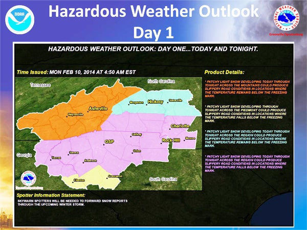
National Weather Service Outlook
By Leah Justice, Kiesa Kay and Samantha Hurst
Wet, gloppy snowflakes began to fall on Melrose Mountain in Tryon at 11:15 a.m., and the wind began to howl as area residents made plans to stock up on bread and milk before the predicted multiple-day winter storm set into the area.
The storm has been named Pax, which is predicted to bring snow and ice to parts of the south through the middle of the week with what forecasters are calling a “one-two punch.”
Predictions differ among the various news outlets. Some say the storm would start Monday, Feb. 10 with freezing rain and end Thursday morning. Others are predicting a wintry mix beginning on Tuesday, Feb. 11 and another heavier system with mostly snow all day Wednesday, Feb. 12.
According to weather.com, snow and sleet will shift out of Arkansas and Oklahoma into Tennessee and North Carolina Monday night into Tuesday.
Another round of wintry mix is expected Tuesday into Wednesday, with a widespread area of snow, sleet and freezing rain from the southern Appalachians and piedmont of north Georgia and west Carolinas, according to weather.com.
Significant snow, sleet and freezing rain accumulations are possible with this phase of the storm, according to forecasts.
A winter storm watch was in effect from Tuesday morning through Thursday morning from the National Weather Service.
According to the NWS outlook, heavy snow is likely from Cherokee County and as far east as Charlotte, N.C. Accumulations of 6-8 inches are expected along the eastern slopes of the mountains, with 4-6 inches to the northwest of the I-85 corridor and 2-4 inches southeast of I-85.
“The take-away is that although there will be some areas of winter precipitation in the mountains today and then possibly everywhere by Tuesday, the main event so to speak, will occur Wednesday into early Thursday. That is when the bulk of heavy snow and ice should be expected,said Larry Gabric with NOAA.
Patchy light snow developing today through tonight across the region could produce slippery road conditions in locations where the temperature falls below the freezing mark, NWS said.
In the Polk County and Landrum areas, road conditions were of concern for most residents.
The N.C. Department of Transportation (DOT) in Columbus treats primary roads as soon as snow or ice accumulation begins. The Columbus office said on Monday their trucks and staff were ready to go as soon as it starts snowing or sleeting.
The DOT treats and removes snow from Polk County’s main, or primary roads, including Hwy. 108, U.S. 176, Hwy. 9, I-26 and U.S. 74, among other state-owned roads. Treatments are done with salt, according to the Columbus office.
Temperatures will be key in the next few days, with an 70 percent chance of snow on Tuesday, Feb. 11, a high of 38 degrees and a low of 27 degrees, according to weather.com.
Wednesday’s high temperature is expected to be 30 degrees with a low of 27 degrees and 70 percent chance of snow for the Tryon area, according to weather.com.
Thursday’s forecast also calls for a few snow showers (30 percent chance) with a high of 44 and a low of 21 degrees.
“We’ve got our employees on standby,” said Penny Storey with Polk County EMS. “Depending on the weather, they might spend the night here, and the night crew might spend the daytime here. We’re ready.”
Officials for Spartanburg County School District One, which serves Landrum, had not made a decision about closure as of Monday afternoon.
Polk County Schools sent Saluda students home at 11:30 a.m. Monday, Feb. 10, but Superintendent Bill Miller said they were keeping their eyes on the weather before closing the rest of the system’s schools.
Check back with the Tryon Daily Bulletin at www.tryondailybulletin.com for continuous updates.
Check back with the Bulletin at www.tryondailybulletin.com for continuous updates.
More News


-
Polls
 Loading ...
-
-