The view is worth the hike to Looking Glass Rock
Published 10:00 pm Wednesday, July 20, 2016
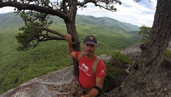
The view from atop Looking Glass Rock.
I have viewed a huge granite monolith from the Blue Ridge Parkway for several years. I had planned to stand on top of it someday, and that day finally came.
Looking Glass Rock, a very unique mountain that rises just south of the parkway in the Pisgah National Forest, is quite the site to behold. While I will admit, it is much better to understand and behold the impressiveness of this “rock” from the Looking Glass Rock overlook, at milepost 417 on the Blue Ridge Parkway. The overlook gives a great view of the mountain, and the massiveness of the rock face and sheer wall it creates.
Maybe curiosity, or maybe just because it was there, or just to do it, I wanted to hike the popular mountain to see it from its point of view. I’m not sure of my motive.
The trail starts near the Pisgah Center for Wildlife Education, also known as the Pisgah Fish Hatchery. It’s definitely all uphill from there. The trail is 3.1 miles in with a 1,500 ft. elevation gain. The trail is rated by most as difficult, but I felt it was a very good trail. I ‘m guessing the rating is based on the length combined with elevation gain.
There are some things to view along the way, like a few coves or “hollers” that offer a look into the forest. There is also an opening on the south face that is a huge rock, flat and big enough to be used as a helicopter pad for mountain rescues.
There are a few pig trails off to the side that probably lead to somewhere but I just stayed the course. A fair portion of the trail is walled by Rhododendron and Laurels, making for a poor view but excellent sections to put your head down and cover ground.
You actually top out on the peak of the mountain about three miles in, and then descend the other side a short distance to the north facing sheer rock. The trail comes out of one of the Laurel “tunnels” onto the rock where the view makes you stop for a moment and say “Wow!”
The rock face is popular for rappellers and climbers, and not for those scared of heights. Those with respect of heights or fear of falling may want to stay at the very top edge where the trail comes onto the rock, you can get reasonably close to the edge but you get a real sense of the sheer drop of at least 500 feet!
To get there take I-26 to Hwy. 64 in Hendersonville. Take 64 toward Brevard until the intersection with Hwy. 276. Stay straight at the red light onto 276 and enter the Pisgah National Forest. Go about five miles after you turn on 276 and turn left on Forest Service Road 475. The parking area for the trail is about 4/10 of a mile on your right.
The trail is a very popular one so go early or off-season. I’d guess this rock to be slippery on a wet or frosty day.
More COLUMNIST -- FEATURE SPOT


SportsPlus
How to Watch MLB Baseball on Friday, July 26: TV Channel, Live Streaming, Start Times
In a Friday MLB schedule that features a lot of thrilling contests, the Cleveland Guardians versus the Philadelphia…
How to Watch the Braves vs. Mets Game: Streaming & TV Channel Info for July 26
Travis d’Arnaud and the Atlanta Braves square off against Pete Alonso and the New York Mets at Citi…
Braves vs. Mets: Betting Preview for July 26
On Friday, July 26, Francisco Lindor’s New York Mets (54-48) host Marcell Ozuna’s Atlanta Braves (54-47) at Citi…
Atlanta Falcons vs. New York Giants Week 16 Tickets Available – Sunday, December 22 at Mercedes-Benz Stadium
On Sunday, December 22, 2024, the Atlanta Falcons (0-0) and the New York Giants (0-0) clash at Mercedes-Benz…
Carolina Panthers vs. Kansas City Chiefs Week 12 Tickets Available – Sunday, November 24 at Bank of America Stadium
Sunday, November 24, 2024 will see the Carolina Panthers (0-0) go on the road to meet the Kansas…
-
Polls
 Loading ...
-
-