Green River watershed assessment underway
Published 9:46 pm Wednesday, July 24, 2013
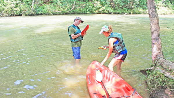
Zan Price and Natalie Bouchard with Altamont Environmental took to the Green River Saturday, July 20 to begin the consulting firms in-field study of the waterway as part of the Green River Watershed Alliance assessment. The assessment is funded by a grant from the N.C. Department of Environmental and Natural Resources (NCDENR).
Altamont Environmental engineers last week launched field study work on an assessment of the Green River watershed.
The assessment, funded by a grant from the N.C. Department of Environmental and Natural Resources, aims to document present conditions of the watershed.
“Before we can come up with any watershed plan, we have to have the baseline; we have to have the hard facts and know what problems there are so we can create a plan to deal with them,” said Green River Watershed Alliance founder Sky Conard.
Conard has recently implored area residents to become more knowledgeable about what she says are erosion and sedimentation concerns along the Green River and on Lake Adger.
GRWA received a $15,000 grant to fund the assessment last year. The grant is being administered through the Isothermal Planning and Development (IPDC).
Green River Watershed Alliance and the engineers toured Lake Adger July 20 on a pontoon boat, kayaked the Green River from Big Rock into Lake Adger and then hiked accessible portions of incoming tributaries; Bright’s, Ostin, Silver, Panther and Rotten Creeks.
Conard said none in the group were capable of staying dry as afternoon skies delivered thunderstorms and the group had to seek shelter. The assessment work continued Wednesday, July 24 at Austin Creek.
“They want to see where all the possible stressors are that could cause a build up of sedimentation,” Conard said.
Polk County owns the Lake Adger basin with plans to use the lake as a future drinking water reservoir. The Green River Watershed is a sub-basin of the Broad River basin, with 42 percent of the watershed located in Polk County (36,825 acres) and 58 percent of the watershed located in Henderson County (50,645 acres), according to Conard’s presentation to commissioners in April 2013.
All shareholders of the watershed – residents, environmental agencies and recreational users – are now asked to provide their input. Conard said the Green River Watershed Alliance encourages anyone interested to provide pertinent historical data, photos and observations of the Green River and Lake Adger.
This information can be sent to Natalie Bouchard at nbouchard@altamontenvironmental.com.
“All contributions help with the accuracy of this assessment/documentation phase of the grant and will ultimately help address, effectively, the issues that our Green River Watershed faces after 88 years of little protection,” Conard said.
Study results will be made public information through a study website and could be used to supplement the N.C. Department of Water Quality Broad River Basin-wide Plan, according to Conard. The grant work is due in Sept. 2013.
More News


SportsPlus
How to Watch the Braves vs. Mets Game: Streaming & TV Channel Info for July 27
Tylor Megill is starting for the New York Mets on Saturday against Travis d’Arnaud and the Atlanta Braves.…
How to Watch MLB Baseball on Friday, July 26: TV Channel, Live Streaming, Start Times
In a Friday MLB schedule that features a lot of thrilling contests, the Cleveland Guardians versus the Philadelphia…
How to Watch the Braves vs. Mets Game: Streaming & TV Channel Info for July 26
Travis d’Arnaud and the Atlanta Braves square off against Pete Alonso and the New York Mets at Citi…
Braves vs. Mets: Betting Preview for July 26
On Friday, July 26, Francisco Lindor’s New York Mets (54-48) host Marcell Ozuna’s Atlanta Braves (54-47) at Citi…
Atlanta Falcons vs. New York Giants Week 16 Tickets Available – Sunday, December 22 at Mercedes-Benz Stadium
On Sunday, December 22, 2024, the Atlanta Falcons (0-0) and the New York Giants (0-0) clash at Mercedes-Benz…
-
Polls
 Loading ...
-
-