The Eye in the Sky
Published 12:23 am Tuesday, March 1, 2016
By Kirk Gollwitzer
If ever there has been a consumer product that was born under a bad sign, the drone would win with flying colors. The word itself connotes bees, male wasps, ants, and unmanned aerial combat vehicles, and so the flying camera has drawn much criticism.
Just a few years ago, it was rare to see a remote controlled model airplane. But, like the model train, they’ve all been relegated to the hobby graveyard and replaced with something much more interesting: an iPhone. Besides, model airplanes were primitive in technology, difficult to fly, and had nothing at all to do with social media!
Then along came the drone, or unmanned aerial vehicle (UAV), the most popular consumer electronics toy of the day, manufactured mainly by the Chinese.
One such Chinese company, Da-Jiang Innovations (DJI), provides a full line of commercial and recreational UAV’s for photography and videography, and all of their products are controlled by an iPhone or Android device. Their drones range in price from $600 to north of $1,000.
On the low end of their product offerings, the slick little device comes with a 4k UHD video camera and a rechargeable flight battery, which is capable of keeping the unit in the air for almost 20 minutes. A three-axis gyroscopic stabilization gimbal holds the camera stable while it soars high above the earth, as it is controlled by a human on the ground, and linked to a constellation of satellites.
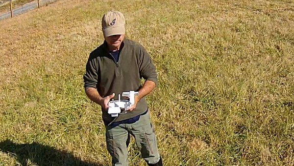
The concept is actually really cool! Three components come into play: the handheld controller, an iPhone and the drone itself. Through the use of joysticks, the controller tells the drone to go up or down, turn on its axis from left to right, and move forward or backwards.
While the controller communicates with the drone, much like a computer might communicate with a wireless printer, the iPhone, clipped to the controller, talks directly to the camera attached to the drone. Meanwhile, satellites in space connect to all three components and oversee everything.
The satellite connections are crucial for the novice pilot, because they provide the majority of control over the aircraft. If the pilot panics and lets go of the joysticks, the drone will remain stationary in the sky until it realizes that there is a problem on the ground. Control then switches over to the drone as it creates its own flight plan and safely returns home.
But even with all of these technological flying wonders, the consumer population continues to shun these flying contraptions as being high-tech “peeping toms” which should be shot out of the sky by a registered gun owner. Sadly, there’s good reason for this ridicule mainly because of the careless human on the ground controlling this technological wonder in the sky.
Therein lies the familiar question: do drones invade people’s privacy and cause a physical injury or do the careless humans on the ground?
Just as there are irresponsible gun owners, there are an equal amount of thoughtless drone owners who disregard safety measures as they modify their drones to do the unthinkable. They boost motor power, amp up battery storage and modify the communication frequencies allowing the drone to fly completely out of sight.
It’s the human on the ground that finds ways to attach automatic pistols to their drones and remotely fire them at their neighbor’s homes, or finds ways to fly their tiny aircrafts at altitudes exceeding 1,200 feet, over major airports, sold-out stadiums or the most sought after travel destination of all — the White House.
Power always corrupts when a groundbreaking piece of technology makes its way into the idle hands of the consumer. Not sometimes, but always, someone finds a way to ruin the fun for everyone. Remember the laser pointer?
So, along comes the government in the form of the Federal Aviation Administration to save the day. Their solution is easy: make it a crime for any UAV owner to fly their drone (weighing between 0.55 and 55 pounds) above 300 feet, around crowds, near airports and a long way from the president of the United States. The FAA requires the pilots to be registered with the agency and take an oath of safety. Everyone who flies a drone must send $5 to the FAA or face a hefty fine anywhere from $27,500 to $250,000 or accommodate a prison cell somewhere in the vicinity of Bernie Madoff.
But there’s also good news.
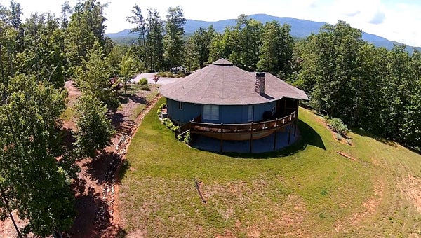
Lake Adger property
A responsible human on the ground, who follows the rules and respectfully works their way through a moderate learning curve, can derive an incredible amount of enjoyment and value from drones.
There is no question that the drone is a wonderful tool for business, advertisers, filmmakers and realtors. For the realtor, it’s a slam-dunk. Providing a prospective buyer with a very cool aerial shot of their listing is nothing short of amazing.
Still, most realtors shy away from aerial photography or video of any kind. They continue to believe that a single flat photo of the property taken from the side of the road will suffice.
“It’s the price and location that sells real estate, not some fancy video,” the frustrated customer is told as they walk out the door and down the street to a realtor who puts a little skin in the game and appreciates quality pictures and video.
Certainly, available satellite imagery can suffice, but those images are always dated and are not even close to the quality of a photo taken by a drone.
Kathy Toomey of Tryon’s New View Realty has used drone video for a year and considers them to be her good luck charms.
According to Toomey, “Property images and videos produced by a drone bring a higher level of detail to a listing’s presentation. It’s especially effective for online marketing because you can capture the buildings and the scenery in one shot. You may only have a short time to grab a viewer’s attention so why not use the best shot possible? Drones provide that extra edge!”
Using this technology to inspect property erosion concerns, fencing design ideas or prime building locations, a drone will deliver a photo far exceeding any land-based camera. Farm owners with missing cattle, horses or donkeys can also benefit from a quick overhead drone survey.
One last thing should be considered if you are considering purchasing a drone. A reasonable amount of skill with video editing is required. Do not expect that all of your footage will look as clear and pristine as advertised. Remember, it’s a demo and there’s been a considerable amount of tweaking and color adjustment.
In closing the drone is a magnificent piece of technology that requires common sense and care, much like a pilot completes before and during a flight. Don’t be one of those careless humans on the ground! Take time to learn how to use it, and only then will you capture the full value of your investment.
# # #
Here are some simple guidelines to follow in order avoid disaster:
- Always fly in GPS-Mode (rather than manually).
- Always keep the drone within the line-of-sight.
- Never take off with less than six satellites in control of your aircraft.
- Never fly your drone indoors. (I know, right? But people still try!)
- Always charge all components of the drone, including the flight controller and iPhone.
- Always fly in favorable weather conditions.
Did you know?
Roughly 700,000 drones were expected to ship in the United States last year, a 63 percent increase from the previous year, according to the Consumer Electronics Association. Most are “quasi-toy” devices costing around $150, but the price can go up into the thousands for drones that can stay airborne longer, deliver state of the art video and photo capabilities, and increased speed. The North Carolina Department of Transportation’s Division of Aviation requires drone operators to get a permit for commercial and government drone operators. (ncdot.gov/aviation/uas)
Real estate marketing and TV/video/movies are perhaps the most well-known of uses for drones, but there are a plethora of other uses currently being employed by a range of government, civilian, research and business entities.
Law enforcement: Search for missing people (drones can be equipped with heat seeking capabilities), monitor traffic accidents and roadways, capture crime scenes
Park management: Capture poachers, find stranded hikers, monitor wildlife populations
Product delivery: Deliver packages and mail
Meteorological: Hunt hurricanes, chase storms
Insurance industry: Monitor natural or man-made disasters or accidents
Construction: Inspect roofs or other hard to reach structures
Agriculture: Monitor crops for water or fertilizer needs
Mapping: 3-D mapping, forestry or deforestation, archeological site, property surveys
Utilities: Inspect power lines and water towers, detect solar panel outages, monitor oil pipelines or oil spills
About Kirk Gollwitzer
Kirk Gollwitzer is a freelance writer frequently writing articles for Google News Service, and other media organizations. After a successful career in software development, Kirk found his true passion telling a story through writing, photography and video. He is constantly projecting people, products and ideas into the national media. Kirk has a passion for music and major interest in people. He is also writing a novel which will be adapted to a screenplay.
 More by Kirk
More Life in Our Foothills Magazine


-
Polls
 Loading ...
-
-