Landrum, Campobello among Upstate Forever’s ‘special places’ to preserve
Published 7:16 pm Friday, March 19, 2010
Upstate Forever has identified the Landrum and Campobello area as one of six “special places” in Spartanburg County that should be preserved.
The nonprofit conservation group released this week “The Special Places Inventory of Spartanburg County” to assist current efforts toward “stronger land use planning” in the county.
Upstate Forever says its important to inventory special places “before the iron tread of progressive civilization leaves them, in the prescient words of John Henry Logan, well nigh wasted and ruined.”
“It is our goal to document our remaining historical and natural assets before we make decisions that could negatively impact those resources permanently,” says Upstate Forever in the report. “By making this information accessible to the public, we hope to raise awareness and promote community involvement in protecting the remaining natural and historic gems.”
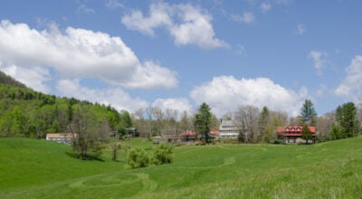
Upstate Forever says the Landrum and Campobello Conservation Focus Area (CFA) has some of the most biologically significant sites in the county. The area, which has a total of 13,535 acres, scored high in Upstates study in Species Richness, Land Cover and Rare Plants. Those findings mirrored a study done previously on the area by the Pacolet Area Conservancy.
The five other areas in Upstate Forevers inventory of special places are: North of Pacolet; Croft and southeast of Glenn Springs; Tyger River; Enoree; and North Tyger River and Ferguson Creek.
The conservation focus areas have a combined total of 67,140 acres.
Upstate Forever took an objective approach when compiling its list and included numerous factors that make a place worthy of “protection, additional study, and conservation.”
Upstate Forever says, for the purpose of its inventory, areas were measured on five major factors: vegetative land cover, species richness, stream systems, rare plants and population density.
“It can be quite easy for one to begin to make arbitrary decisions about what places deserve protection based upon personal experience,” says Upstate Forever, which clearly outlines the specific methodology of its indexing system. “It is our hope that such transparency in this modeling process will illustrate the lengths to which we went to avoid being arbitrary or subjective.”
The study includes information about historic sites, but they were not given an objective value when measuring the areas.
The report lists several historic sites in the Landrum and Campobello area, including the Landrum Railroad Depot, Gowans Old Fort, Four Columns, Earle House, Redlands, Site of Ingleside and Ruins of Fagans Mill south of Campobello.
Below is specific information about the Landrum and Campobello Conservation Focus Area as presented in the Upstate Forever report.. Visit www.upstateforever.org to view the full report.
&bsp;
Landrum and Campobello CFA: Total acreage: 13,535
The northern part of the county is home to some of the most biologically significant sites identified in this model; it is also the most studied CFA. In 1994, the Pacolet Area Conservancy (PAC) commissioned a study of the area around the headwaters of the North Pacolet River in southern Polk County, NC and northern Spartanburg and Greenville Counties (not to be confused with the town of Pacolet in a separate CFA in the southern part of the county). This study identified significant natural areas and ecological resources in the region. In addition, a botany study of the 1,200 acre Fairview Farms tract was completed just a few years ago.
These individual findings could not be included in this model for data consistency reasons (similar studies do not exist for the rest of the county and would have unfairly weighted this region), but merit attention.
Even without the addition of this data to the model, the Landrum and Campobello CFA boasts the six highest scoring individual points in all of the CFAs out of a total of 474,967 points identified in the model.
The Species Richness, Land Cover and Rare Plants layers mirror the findings of the PAC study sufficiently to demonstrate the special qualities of this area. Of particular note are north-facing slopes, seepages, and sheltered areas that encourage rich soils and unusual plant communities, including the threatened species Hexastylis nanifl ora (dwarf heartleaf), Monotropsis odorata (pygmy pipes), Lonicera fl ava (yellow honeysuckle), Fothergilla major (mountain witchalder), Aconitum uncinatum (southern blue monkshood), and Solidago bicolor (white goldenrod).
(Note: a seepage is not a spring. It is where rainwater permeates the soil on a hill until it reaches an impenetrable layer. The water then moves laterally until it reaches the slope surface where it seeps out of the soil. If the water seeps through limestone and picks up minerals, then the seepage will support a biologically rich habitat called a fen.)
The western portion of this CFA is home to two significant areas, identified in the PAC study as the Branch Creek Natural Area and the Ingleside Seeps and Bluffs. They are the only two sites in the state where Hexastylis nanifl ora (dwarf heartleaf) and nestronia umbellula (leechbrush) are co-located. Both sites feature north-facing slopes (bluffs at Ingleside), seeps and acid soils. White oak, tulip poplars and beech dominate the canopy and mountain laurel is found here as well.
Historic sites include Gowans Old Fort, though only an approximate location is known. Gowans Fort was originally built as a defense against the Cherokee and was used extensively during the Revolutionary War.
The eastern portion of the CFA includes the North Pacolet River and Page Creek. Almost one quarter of this portion of the CFA is characterized by mesic deciduous forest, ranked highest of the various vegetative cover types by our biology experts. North-facing slopes are common, as are both acid and base soils.
Tulip poplar and red oak are found throughout, while the acid soils feature white oak and the base soil areas support beech, white ash and the uncommon white walnut. Areas of mixed hardwood include Virginia pine and shortleaf pine. Dwarf heartleaf and mountain laurel are also found here.
The eastern section of the CFA was home to Baylis Earle (1734-1825), once one of Spartanburg Countys largest landowners. The area became known as “Earlesville” until the 20th century. The antebellum historic Four Columns was built in 1777. Nearby is the historic battle site, “Earles Ford,” at a crossing of the Pacolet River (where Highway 14 crosses it today). This battle, a moving skirmish from the river down to Fort Prince in July of 1780, ended in a Patriot victory credited with providing momentum for the subsequent victory at Cowpens. This area also contains evidence of prehistoric populations.
Projectile points, studied as a result of this project, date as far back as the Middle Archaic period (up to 7,000 years Before Present, or BP).
More News

-
Polls
 Loading ...
-
-