Five foot draw down leaves Lake Adger lacking
Published 12:00 pm Wednesday, July 23, 2014
A five-foot drawdown of the water level in Polk County’s Lake Adger, has revealed the high level of sedimentation that a professional study and subsequent report on behalf of Green River Watershed Alliance (GRWA) found in 2013.
That report, Assessment of the Green River Watershed: A Supplement to the NCDWQ Broad River Basinwide Quality Plan, was prepared by Altamont Environmental, Inc. (GRWA assisted with research, implementation, and field work). The project was funded through 2012 Clean Water Act 205(j) grant by NCDENR/DWQ. It noted various sources of sedimentation, lack of riparian (stream bank) vegetative buffer zones, and pointed out sedimentation from those sources collecting in Lake Adger.
GRWA Director Schuyler (Sky) Conard noted that Northbrook Hydroelectric, the operator of the hydroelectric generating station at the Turner Shoals Dam, which holds back the waters of the Green River to form the lake, had lowered the water level by five feet, so that the company could perform electrical repairs at the structure. She said that Polk County purchased Lake Adger and Turner Shoals Dam from Northbrook in 2009, and is responsible for costs of maintenance.
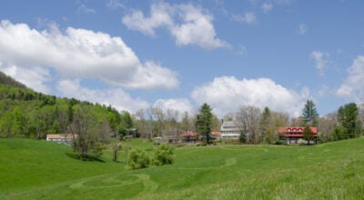
Photographs taken on Monday, July 21, show that the end of the lake downstream of Lake Adger/Silver Creek Road is divided into large amounts of collected sediment, and a smaller area of shallow water adjacent to the lake’s public marina. Islands, formed from sediment, have also grown in what was once deeper water.
Except for a narrow, shallow and likely non-navigable channel of water connecting the marina to the main portion of the lake, the marina appears essentially landlocked from deeper water.
Conard speculated that given the silt load in the upper part of the lake (upstream from the dam, that the eighty-nine-year-old dam would likely have high sediment buildup, and face greater pressures than from the nearly pure water that formed the lake in 1925. If the upper portion of the lake bears such heavy siltation, “You can pretty well assume that something’s going on (at the base of the dam),” Conard remarked. “It (filling with silt) is the normal evolution of a man-made lake,” she continued, pointing out, as studies have indicated, that human activity has hastened this natural progression.
“We have no ordinances to protect it (the lake and upstream portions of the watershed),” Conard added. She pointed to a 2011 report issued by Calvin Bradley, then a retired engineer from Duke Energy. Conard related that the report states that divers working for Bradley found a depth of water of only some thirty-seven feet at the dam, presumably above a large amount of sediment. The dam stands some eighty-seven feet tall.
We know,” Conard said, “from the AECOM 2014 Dam Safety Inspection report that there is unknown debris observed against the arches and bulkheads.” She noted that a Bathymetric Survey (Sonar) would need to done to determine if this is indeed sediment. However, she said that the majority of the current Polk County Board of Commissioners voted to reduce the dam budget, so this study might not be conducted.
While some of the siltation in the Green River Watershed originates, as does the river itself, in Henderson County, rain events show sedimentation in GRW streams that lie entirely in Polk County, including Cove Creek, on which Little Bradley Falls and Big Bradley Falls are located.
Green River Preserve, a 3,400 acre site in the southwest corner of Henderson County, protects the river’s headwaters, many tributaries, and surrounding forest. Some three miles downstream of the headwaters, beyond the preserve’s boundary, water quality is subject to the activities of individual private landowners, before the river enters Lake Summit, several miles west of Saluda, in Henderson County.
In Henderson and Polk counties, the Green River attracts thousands of kayakers, canoeists and other recreational floaters each year, while the river and many of its tributaries, are sought by anglers. On Monday, an angler from Concord, N.C. stopped at Lake Adger looking for a place to fish, discovering instead shallow water and a landscape of silt deposits. With fly-fishing experience on many streams in the East, he was upset with what he found. “It’s ridiculous,” he stated. Referencing Polk County officials, he added, “Their shortsightedness is killing them.”
Watch for updates in upcoming issues of the Tryon Daily Bulletin.
More News


-
Polls
 Loading ...
-
-