Green River Watershed assessment available to public
Published 10:44 pm Thursday, January 9, 2014
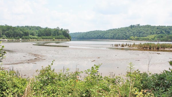
Sedimentation built up in Lake Adger this past July after heavy rains filled waterways. The assessment of the Green River watershed said sedimentation is one of the main concerns in tributaries. (photo submitted)
From world-class whitewater kayaking to hunting in rugged wooded terrain and trout fishing in cold mountain streams, area residents and visitors are blessed with a wealth of active and passive recreational opportunities in the Green River Watershed (GRW).
However, the 2013 Green River Watershed Assessment (visit
www.regionc.org/Planning/Docs/Report%20Green%20river.pdf) carried out through the Green River Watershed Alliance (GRWA), pinpoints numerous concerns, including water quality issues in many parts of the basin.
In particular, the study, prepared by Altamont Environmental Inc. of Asheville, found sedimentation (soil carried away by erosion, and deposited in waterways), the number one pollutant in North Carolina waterways. Erosion is common in numerous tributaries of the Green River and in the river itself (including in Lake Adger).
According to a summary of the report, sedimentation “severely impacts aquatic life and wildlife habitat, degrades water quality, carries harmful chemicals and nutrient pollutants, and negatively affects recreation, navigation, property values, water treatment systems (increases costs to clean and filter drinking water), hydroelectric plants operation and water storage capacities (sediment fills in reservoirs and increases costs to produce electricity). Sediment loads matter because it directly affects our Green River watershed health and our pocket books.”
Green River Watershed Alliance (GRWA) founder Schuyler (Sky) Conard said prior to this assessment, very little data existed to identify or quantify issues.
Conard noted the irony of having such a wealth of recreational opportunities, but little data, and scant resource protection to ensure that those opportunities exist far into the future.
Protecting the resource is a win-win, Conard and the report note, as best management practices for protecting streams and rivers return economic benefits to residents.
The study, completed in September 2013, was limited to a 60-square-mile area within the entire 245 square miles of the GRW, because of funding limitations.
The Green River, from the county line at the Narrows down through Lake Adger, includes the following tributaries: Casey Branch, Brights, Cove, Gadd, Ostin, Panther, Pulliam, Rotten, Rash and Silver creeks. All together, about 182 stream miles were studied. Altamont identified and examined existing conditions of 31 sites along the waterways.
The report notes that of the 31 sites, 22 exhibit signs of erosion, channel incision and sediment accumulation. Potential for large, heavily sediment depositional islands was observed at Panther and Ostin creeks and the Green River entrances and public marina to Lake Adger, as well as throughout the lake.
Coves of Panther and Ostin creeks, and Bright’s Creek (at confluence with the Green River) were filled heavily with sediment. Rotten Creek was also observed to be largely impacted by sediment pollution. It is a matter of time before the public marina is cut off from the lake and Green River because of the growing/expanding sediment, according to the report.
Much of the Lake Adger shoreline is eroded, stressed/unstable and tall, near vertical banks. This contributes to sediment into the lake. Water shallowness was observed throughout the public marina and at multiple tributary entrances, the report said.
Sediment accumulation in the lake is likely attributed to lake shoreline erosion, unstable/eroded stream tributaries, upland current and historic development and land clearing within the GRW.
Damming the Green River 90 years ago prevented the contributing streams to carry and transfer their sediment loads from the watershed so all sediment deposits and erosion accumulate in Lake Adger.
As the Green River approaches Lake Adger, the channel slope and velocity decrease, and the channel substrate changes from boulders and cobble to sand bed. Large sediment deposits were observed, said the report.
Causes or stressors of sedimentation identified were lack of riparian (stream-side) buffers, construction activities past or present, livestock creek access, actively eroding hillsides and banks, runoff from agriculture areas or eroding bare dirt/gravel roadsides or parking lots, clear cutting and stream morphology changes over time (90 years post construction of dam).
Water quality data within the GRW study area was not abundant and there is no ambient water quality monitoring, the report said.
The project was funded through a 2012 Clean Water Act Section 205(j) Grant by the North Carolina Department of Environmental and Natural Resources, Division of Water Quality (now DWR) for the “Assessment of the Green River Watershed: A Supplement to the NCDWQ Broad River Basin.
The impacts become more clear, the report says as Polk County moves closer to reclassifying waterways for public drinking water.
In spite of the resource base, and the risks presented by sedimentation, no watershed assessment team projects (WAT), watershed assessment and restoration programs (WARP) or local watershed plans (LWP) exist in the Green River Watershed, according to North Carolina Department of Environment and Natural Resources/Department of Water Quality NCDENR/DWQ).
The 2008 NC DWQ Broad River Basin Plan/Green River Watershed is the most recent basin plan available. Updates were due in 2013 (five-year cycles), but were changed to 2018 (10-year cycles).
Recommendations include:
Stop further sedimentation by adopting best management practices (BMPs), whenever and however the county can. Sediment is being continually supplied to the streams, Green River and Lake Adger.
Stabilize exposed soil throughout the Green River Watershed. Reducing sediment would preserve the water quality and the recreational resource of the Green River and Lake Adger. Examples are: bioretention basins and storm water wetlands, cattle exclusion fencing along streams, stabilizing exposed and vulnerable soil slopes and Lake Adger shorelines.
Restore eroding lake and stream banks and riparian buffers. Utilize low impact development strategies like proper silt fencing, erosion control techniques, preventing road runoffs, maintaining buffers and avoiding steep slope grading.
Remove sediment by dredging. Lake Adger has not been thoroughly dredged since its construction in 1925 and this reduces the storage capacity, and is a nuisance to residents and recreational users of the reservoir. Conduct a dredging analysis/plan to determine optimal and priority locations in the lake to remove the sediment. Public marina, Panther and Ostin Creek entrances to lake are critical.
Investigate further the stressors identified in report and partner with the other stakeholders to implement the BMPs that would remediate the problems while improving the water quality within the watershed.
Conard said the importance of the study lies in the fact that it is the first official documentation of the present reality of conditions and lack of data available for the Green River Watershed within Polk County. She said the report serves as baseline information that will require further intensive studies.
“A great paradox on the Green exists… while its notoriety, popularity and human prosperity continue to grow exponentially from … the International Green River Narrows (kayak) Race, Green River Games, Green River Adventures, Gorge Zip Line, Green River Gamelands, Lake Adger reservoir and community (hydroelectric power dam and the eventual drinking water source for the county)… the monitoring, protection, proper management and needed restoration for it has not even begun,” Conard said. “What an enigma that this internationally famous Green River is apparently really a forgotten Green River.”
Conard said it is the mission of the Green River Watershed Alliance to change this course.
“Water resources are precious; they are not inexhaustible, immune to deterioration from the inevitable bane of erosion/sedimentation pollution or able to just manage themselves,” Conard said. “We humans, all stakeholders of this great asset need to balance the scales and give something back, invest some work and efforts to address these ever pressing problems.
“GRWA tries diligently to be a voice for these waters.
The GRWA is a grass-roots, citizen-led organization, that has been addressing the need to build, collaboratively, an economically sound (smart), conservation based (green infrastructure) management plan for our Green River for the last four years.
The plan aims to promote clean water, responsible stewardship and the sustainability of these waters for generations to come.
“Water is life,” Conard added.
More News


-
Polls
 Loading ...
-
-